
From city street signs to the components of our smartphones, location has always been the building block for data. A navigation app can provide turn-by-turn directions and avoid impacts on travel. Packages travel from warehouses and are delivered to doorsteps or secured lockers in dense business districts. Each information system has its own rules for data privacy, but the sharing of data is inevitable with the creation of new datasets every day.
The transportation sector has long suffered from a lack of standard integration. Various modes of transportation such as buses, connected vehicles, and even electric scooters are often managed by different companies, with disparate APIs and a lack of common language. This fragmentation has created a siloed experience for customers and has hampered the industry’s ability to deliver efficient, environmentally friendly services. To address these challenges, emerging software and revolutionizing pilots have been looking to improve interoperability using data standards.
Building Blocks
Geographic Information Systems (GIS) are a powerful tool for understanding and visualizing spatial data, making them indispensable in various fields, from urban planning to environmental management. At the core of GIS are the building blocks of data, consisting of two primary components: spatial data and attribute data. Spatial data forms the foundation, representing geographical locations, shapes, and relationships of physical features in a smart. This includes everything from streets and buildings to natural landmarks and topographical details. By representing the physical world digitally, GIS allows for the visualization, analysis, and manipulation of spatial data, enabling us to understand a system in a geographic context.
Complementing spatial data, attribute data enriches the framework by providing information about the features represented. These attributes can encompass a wide range of data, from land-use categories in urban planning to transportation characteristics like road network connectivity, traffic flow patterns, or public transit routes. Attribute data is associated with specific geographic locations, creating a bridge between the spatial and non-spatial aspects of the dataset. The integration of both spatial and attribute data is essential for the effective utilization of GIS, as it enables users to answer complex questions, make informed decisions, and derive meaningful insights by linking the “where” with the “what” or “why.” Through the harmonious interaction of these building blocks, GIS plays a pivotal role in addressing real-world challenges, helping us better comprehend and manage the complex spatial relationships that define our transportation systems.
A Common Language
Data standards play a critical role in achieving interoperability in the transportation sector. They ensure that information can be shared and understood by all relevant parties, from transportation providers to passengers. Common data standards allow different systems to communicate effectively, thereby enabling the seamless transfer of information and services. The use of standardized data formats, protocols, and interfaces makes it possible for transportation systems to function as a cohesive whole.
One of the critical areas where data standards are making a significant impact is in the creation of ground truth data. An entire working system that has been established for years can be transformed into a system of the future. Single space locational data can be evolved to allow for different modes of transportation to all use the same geographical areas. A single-use curb space can now be developed into a multiple-use flex zone. By building on common languages with the use of GIS, users can unload goods in the mornings, park vehicles in the afternoon, and use the same area for rideshare pickup and drop-off in the evenings.
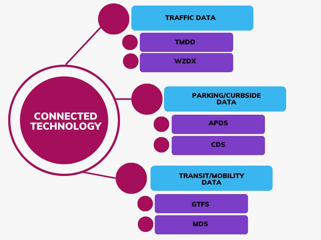
Moreover, data standards are essential for real-time information sharing. Whether it’s the current location of a streetcar (General Transit Feed Specification or GTFS), off-street parking availability (Alliance for Parking Data Standards or APDS), work zone management (Work Zone Data Exchange or WZDx), or use of the curb (Curb Data Specifications or CDS) passengers rely on accurate, up-to-date information to plan their journeys. Data standards ensure that information can be shared across different platforms and apps, providing travelers with the latest information to make informed decisions. This not only reduces the uncertainty and stress associated with travel but also contributes to a more efficient and resilient transportation network.
Challenges and Considerations
While the vision of an interoperable and standardized transportation system is promising, several challenges and considerations need to be addressed:
- Privacy and Security: As transportation systems share more data, it becomes crucial to protect user information. Robust security measures and privacy safeguards are necessary to prevent the misuse of personal data.
- Legacy Systems: Many existing transportation systems operate on outdated technology and infrastructure. Transitioning to modern, interoperable systems can be costly and challenging.
- Regulatory Barriers: Regulatory hurdles can impede the adoption of interoperable technologies and data standards. Policymakers must work in tandem with the industry to create a supportive regulatory environment.
Moving Forward
As we set our sights on the road ahead, it becomes increasingly apparent that a future defined by seamless travel, empowered by interoperability, is not only achievable but essential. The cooperation of public and private sector stakeholders is paramount as we navigate the path toward integrated solutions and standardized data practices. Leveraging GIS as a source for data building blocks can improve user experience while fostering reduced congestion. The transportation landscape is poised for transformative change, where an interconnected network will empower passengers, optimize efficiency, and contribute to emerging technologies. With dedicated strategies and resolute commitment, we can turn the dream of frictionless travel into a reality, propelling us closer to the innovative transportation system that awaits on the horizon. ◆

Jacob Larson serves as Applications Analyst for the City of Omaha—Parking Division and a member of IPMI’s Technology Committee and Smart Transportation Task Force.


-
Jacob Larsonhttps://parking-mobility-magazine.org/author/jacob-larson/

-
Jacob Larsonhttps://parking-mobility-magazine.org/author/jacob-larson/