


It’s no secret that congestion and related issues are leaving drivers in our cities feeling “stuck at the curb.” As a causality, most will point to Shoup’s often-cited statistic that nearly 30% of urban congestion is created by drivers cruising for parking. Yet that was published in 2005, and some of our cities have grown by as much as 10% year over year, likely leading to higher congestion levels, especially in major metropolitan centers. In response, there has been an influx of emerging technologies, task forces, and research grants to address the congestion that plagues our streets and curbs.
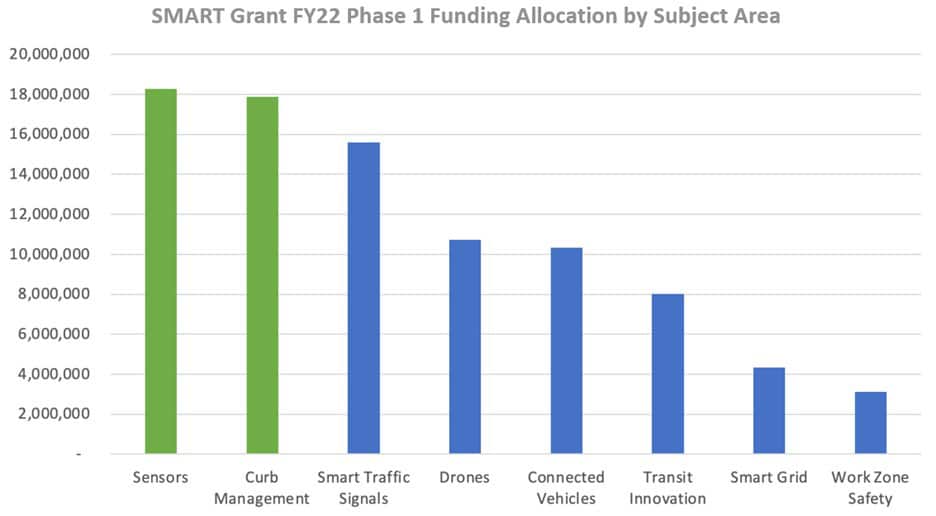
Most recently, the USDOT created the $96 million-dollar SMART Grant to aid cities in their endeavors to help solve congestion, with 40% of grant funding awarded to curb management and sensor-based projects respectively.
While there isn’t a “magic formula” to solving congestion (yet), there are three ingredients of effective curb management: inventory, insight, and intelligence. These simple components can be utilized no matter the size of the environment or budget and will lead to immediate results getting your curb and streets moving in the right direction.
Inventory
While collecting an inventory of your curb may seem like a simple feat, it is essential to address various congestion-related questions to understand where to start. A solution that can be used is the Curb Data Specification by the Open Mobility Foundation. This specification enables cities to create a digital inventory of their curbs, and offers three main data endpoints: Curbs, Events, and Metrics APIs.
The Curbs API serves as the foundation for publishing curb uses, locations, and assigning policies to zones. It allows cities to communicate different curb regulations effectively through unique curb activities and user classes. Creating a curb inventory by utilizing the Curbs API can be accomplished in multiple ways. An organization can rely on in-house resources and previously collected data to digitize assets. Once features have been translated into geographic polygons, policies or regulations can be assigned. Some development time will be required to tie the policies, activities, and time spans together. Whether the data is in one source or is composed of two databases, the process to map fields between sources is relatively simple due to the design of the spec.
Cities can explore an alternative approach by leveraging existing partnerships with technology providers. Providers may offer pre-packaged solutions that can save time and potentially reduce expenses. While sharing geographical data may still be necessary during planning, the implementation of policies and rates for curbs can be accelerated through a user-friendly interface.
Intelligence
To collect event-level data from technology partners, cities can leverage the Events API. For example, a sensor partner can query a city’s Curbs API to access information about curb locations, usage rates, and vehicles allowed in those zones. This real-time data integration helps cities make informed decisions and manage curbside activities efficiently. Additionally, cities and technology partners can work with delivery providers to directly receive event data through the Events API, enabling them to capture information as delivery activities occur in real time.
To assess and consolidate the event data gathered via the Events API, the Metrics API can be enabled. This API allows users to calculate predefined metrics such as curb occupancy or dwell time. CDS helps cities streamline their curb management processes, understand curb usage patterns, and make informed decisions to improve transportation and alleviate congestion.
Insight
Advances in technology allow municipalities to now have their curb inventory (supported by CDS), garage inventory, occupancy levels of all assets, payment compliance, revenue streams, and violation info live in a single software platform. This is extremely powerful and unlocks insights into parking environments that previously lacked accuracy and transparency. For example, capital expenditures planned for new parking facilities can be postponed or even canceled now that occupancy data reveals that parking assets aren’t available; they’re just underutilized and hard to find. By communicating the availability of said on-street, lot, and garage spaces in real-time to drivers, the congested curb due to cruising can now be utilized for its intended purpose(s).
Case Study
Cologne, Germany sought a solution that would significantly reduce traffic and CO2 emissions, while improving the quality of life in the neighborhood of Nippes. To achieve this, the City needed to implement parking technology to guide drivers to the closest available parking space at every critical decision point. Occupancy and utilization data from overhead sensors needed to provide accurate real-time information on the number, location, and direction of free spaces around the city. Combined with guidance displays, drivers avoided searching for available parking for extended periods of time, improving their overall experience and reducing vehicle emissions.
On-site test drives have shown search time reduced by 45% through providing information about the location of available parking space through the system as opposed to a random search. At the same time, the distance driven was reduced by 41%. In the process, 145 test drives were carried out during the day on weekdays at three different locations and at a parking space occupancy rate between 95 and 99%.
Prior to the installation of the solution, the occupancy rate was at 88% between 10 a.m. and 6 p.m. on weekdays. This result was based on the measurement of 10,000 parking spaces/events. Additionally, after the guidance system was deployed, the parking capacity usage increased by nearly 8 percentage points to 96%.
The results are clear. Integrating these smart curb management solutions has a profound impact not only on the user experience but helps to dramatically reduce the time and emissions spent on the search for parking. As cities continue to grow, the risks of greater levels of congestion grow with them. But the solutions available today to alleviate this congestion will dramatically improve the parking and transportation experience and help to create cleaner and more sustainable communities. ◆

Jacob Larson serves as Applications Analyst for the City of Omaha—Parking Division and a member of IPMI’s Technology Committee and Smart Transportation Task Force.


-
Jacob Larsonhttps://parking-mobility-magazine.org/author/jacob-larson/

-
Jacob Larsonhttps://parking-mobility-magazine.org/author/jacob-larson/


Andrew LaMothe is Vice President of North American Sales & Global Marketing for Cleverciti and is a member of IPMI’s Conference Program Task Force and Technology Committee.
-
Andrew Lamothehttps://parking-mobility-magazine.org/author/andrew-lamothe/

-
Andrew Lamothehttps://parking-mobility-magazine.org/author/andrew-lamothe/


The Digital Tsunami is Here
How Data Standards are Shaping the Future of an Interconnected